

Circularity Atlas
The City Circularity Atlas enables a complete view of the cities. Here spatial analyses and data are displayed, providing an overview of the entirety of cities by combining relevant datasets, satellite imagery sensors and ad-hoc data deliverables. Relevant data is collected through the project as well as gathered from outside of the CIRCuIT project.
Data relevant to circular economy and generated within the CIRCuIT project is accessible through the links below. Different cities provide data with different focuses.
 Circular Applications in London |  Building Categories in Hamburg |  Demolitions in Copenhagen |
|---|---|---|
 Waste received by borough in London |  Building facades in Helsinki metropolitan area | 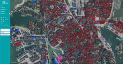 Material of structural systems in Helsinki metropolitan area |
Space Monitoring Service
The Space Monitoring Service delivers processed satellite imagery – through the official Copernicus programme and tailored deliverables for the cities. This data facilitates easier comparison between the project cities, at a city-level scale, and can create new insights of the state-of-the-cities.
The data is available either through the CIRCuIT Atlas application or through a hosted showcase application. Additionally data can be accessed through an API.
 NDVI analysis Copenhagen |
|---|
Showcase
 Showcase Atlas |
|---|